Showing posts with label Illinois. Show all posts

Tuesday, October 10, 2017

A dry spell in Illinois (Springfield to Stauton)


Hello Everyone,

Today I continue talking about my Route 66 trip I did in 2016. In my blog, Flip Flopping’ on my may to Springfield?, I ended with having dinner at the Cozy Dog Inn in Springfield, Illinois. Within Springfield you will find a number of alignments of Route 66. Regardless of which alignment you take on your way out of Springfield, there are only two alignments that go South; IL-4 and Highway 55. 

I choose the IL-4 alignment because there were more geocaches on this stretch versus geocaches on the Highway 55 path. Both will get you to Staunton. 

I drove through the town of Chatham and before I got to the town of Auburn there was a geocache I totally missed, Snell Road or Brick Road (GC6KDN9, hid by Chief STDNMB). This section of Route 66 is made of brick and I heard that if you drive this section that you might want to drive a little slower since some of the bricks are loose.

Then I drove through the towns of Auburn, Thayer, Virden, Girard, and Nilwood. There were a few geocaches scattered here and there, but none of the caches I was driving by had enough favorite points to make me want to stop. Also, I couldn't find any Route 66 related stops. 

After Nilwood there is geocache on an old alignment called, Old Route 66 - Turkey Tracks (GC2HEJV, hid by awanderer, 24 favorite points), and somehow I missed getting this cache on my list for my trip. I did retrieve some pictures from the geocaching page and illinoisroute66.org.


According to illinoisroute66.org, An original piece of the narrow 1926-30 Route 66 alignment winds south of Nilwood, parallel to the current straight configuration IL Route 4. Turkey tracks were imprinted in the 1920's when the original Route 4 concrete was poured, prior to its designation as Route 66. The story varies from a local farmer's escaped turkeys to wild turkeys as being the owners of the prints.”


The Mother Road goes from the Turkey Tracks and into Carlinville. At this point, the sun was going down and I needed to find a place to sleep for the night. I checked the phone and headed for a gem, Carlin Villa Motel. I don’t think it is an iconic stop, but if your travels have you in this general area at the end of the day, try staying here.


I could see this motel turning into a popular place for Route 66 roadies in the future.

The next morning I explored the town of Carlinville for a short while. There is a neat town square you’ll want spend a little time, walk around, see the businesses and pro-Route 66 set ups.

There is a small number of geocaches in town, but the only one I feel is worth getting is Million Dollar Courthouse (GC32CGH, hid by awanderer, 7 favorite points). I couldn’t find it the container, but this time it wasn’t my fault. The geocache went missing and was replace about a week later after I was there.

Here is what the geocache webpage says about the courthouse, In early 1867 local government officials decided to build a new courthouse for Macoupin County. A four man commission was established and the cost estimate was $50,000. Bonds totaling that amount were issued for the project. In October of 1867 the first cornerstone was set in place. The cost escalated dramatically from then on. By January 1869 nearly $500,000 had been spent and building was still not complete. More bonds were issued, and by the time the courthouse was officially completed in 1870, the project had cost a staggering $1,342,000.00. This incredible price inspired the nickname of "Million Dollar Courthouse."

Rumors of misused appropriations also tarnished the project. Initially, the blame was laid on Judge Thaddeus Loomis and George H. Holliday the county clerk. Both men were part of the original four man commission. Judge Loomis was apparently innocent of any wrongdoing but we may never know the truth about Mr. Holliday because one night in 1870, he boarded a train out of town and simply disappeared.

At the time of its construction in 1870, the building was the largest county courthouse in the United States, and larger than the Illinois Statehouse. It is still recognized as the most magnificent courthouse in Illinois.”

I left Carlinville and started to drive to Gillespie. About halfway to Gillespie I stopped at an old bridge that had a geocache, Old Route 66 - Honey Creek Bridge (GC2AF5D, hid by awanderer, 4 favorite points). I grabbed my camera and recorded by find. Below is the YouTube version of it.


I drove through Gillespie and Sawyerville. Shortly after Sawyerville was another geocache I stopped at, Old Route 66 - A Tribute (GC2AM8E, hid by awanderer, 21 favorite points). This geocache is on an earlier alignment of Route 66 which is only about a mile long. It is an interesting tribute and if you go there you’ll see why.
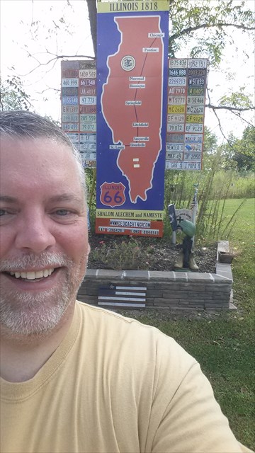

Here is what the geocaching webpage says about it, “This cache has been placed at this spot to make you aware of an interesting Route 66 display. The signboard has been created by Emil Fritz and exhibits the path of Old Historic Route 66 that was in use from 1926 to 1930. Also on display is very nice collection of Illinois license plates from 1948 through 1979. The State of Illinois stopped issuing annual plates in 1979 and initiated the license plate sticker program eliminating the year being stamped into the license plates. Emil, who lived just across the road from the sign, and his sons have spent considerable time creating and erecting this neat memorial.

In September of 2015 Mr. Fritz passed away. He will certainly be missed. Most memorable about Emil was his pleasant good natured and friendly demeanor.”

After I got back on the road, I hit the town of Staunton and that’s where I want to stop for now. I had a great time in Staunton and I get myself a great interview with Rich Henry of Henry’s Rabbit Ranch.

I didn’t go back and do the eastern alignment (Highway 55), but if in the future I do, I am adding these geocaches to my list....

Get Your Kicks on Route 66 (GC17HNQ, hid by NebulousNimrod, 1 favorite point)
RE66:IL The Ariston Story (GC1EJND, hid by Team Route 66/Chod, 32 favorite points)
Old Route 66 - Soulsby Station (GC35A98, hid by awanderer, 40 favorite points) 
RT66:IL Get Your Kicks (GC15THV, hid by Vinpride, 58 favorite points)

Here are geocaches I might also get just because of namesake only. Note, these geocaches were just recently placed and was not available when I was traveling. 

RT 66 second side 3 (GC6W4EB, hid by sewivy)
RT 66 second side 2 (GC6W45W, hid by sewivy)
Another Rt 66 Second Side (GC75R18, hid by sewivy, 1 favorite point)
Rt 66 second side (GC6BTWQ, hid by sewivy, 2 favorite points)
Rt 66 Motel no more (GC6WXHD, hid by sewivy, 3 favorite points)
Rt 66 second side 4 (GC6WXJ4, hid by sewivy)
Rt 66:IL A splitting of ways (GC7CNR1, hid by jvet)
Rt 66 historically speaking (GC6W441, hid by sewivy)

I might also add these caches if I got the time and because they are close to the Mother Road and have some favorite points...

There’s No Place Like Home! (GC2A7PR, hid by off looking, 3 favorite points)
Don’t eat the berries! (GC3YXE3, hid by zackfrillman, 19 favorite points) Only if I am going Northbound on Highway 55
NO LAST CHANCE FOR GAS (GC473CZ, hid my MA PA, 3 favorite points)
Weigh station prairie (GC2BRE3, hid by dver819, 3 favorite points)


That's it for now. Until next time, do me a favor and share this with your Route 66 Roadies and/or Geocaching Pals on your favorite social media.

Speaking of social media, if you haven't done so yet, friend me on Facebook (Rich Havlik) and follow me on Twitter (@richhavlik) to get notifications when I update this blog.

I'd love to hear what you think, so feel free to say something in the comment box below.

I had the time of my life on Route 66. I know you would too. But don't take my word for it, go and experience for yourself.

Peace,
Rich


Tuesday, September 26, 2017

Flip Floppin' on my way to Springfield?

Hello Everyone,

Been a while, eh? Well I took a couple of weeks to travel Route 66. In 2016, I started in Chicago and ended in Miami, Oklahoma. So that’s where I started my travels for 2017. I drove solo from the Minneapolis/St. Paul area to Joplin, Missouri and stayed at a hotel. The next morning, I stopped at a couple of sites on Route 66 that my girlfriend and I missed in 2016 and eventually got to Miami and started fresh for my 2017 trip.

So here is where things might get flip-floppy on this blog. Some entries are going to be about my Route 66 travels in 2016 and some entries are going to be about my trip down the Mother Road in 2017. Don’t worry, I’ll have them clearly mark in the beginning of each blog. But I have a feeling that you’ll be more interested in the towns themselves (and any geocaches nearby) and not so much about being hardcore chronologically.

So here we go....

Driving down the Mother Road in September 2016

In my last blog post, I was in Lincoln, Illinois and then started down Route 66 and drove through the town of Broadwell where there wasn’t much in terms of Route 66 related stops or geocaches. 

I then came to the town of Elkhart. I did stop for a non-Route 66 related geocache, Elkhart Memorial (GC3K78K, hid by SEARCH PARTY, 4 favorite points). It’s a nice little town honor for veterans and the hide itself wasn’t all that remarkable, but stopped at this point because it had more than a couple of favorite points.

I then hit the town of Williamsville. There wasn’t any route-related geocaches, but there is a Route 66 related stop, Old Station.


According to legendsofamerica.com, “Old Station, a converted 1930s service station surrounded by old cars and memorabilia. The inside is a blast-from-the-past, with walls filled with a huge inventory of die-cast cars, Coca-Cola collectibles and Route 66 memorabilia. Open most afternoons.”

But when I got there, no one was around and it looked like it might have been in repair mode.


This isn’t the first time I came across a Route 66 Related stop in a rebuilding state. I also have a feeling it won’t be the last.

I drove on and came into the city of Springfield.

I could only find one route-related geocache in Springfield, so I first went for a heavily favored virtual cache, The Oak Ridge Tour (GCE6FF, set up by Rod & Shelby, 189 favorite points). When I entered into the cemetery, I knew right away I had to take the video camera with me. Below is a YouTube version of my experience there.


It was hard getting upbeat in a cemetery video. Walking through Lincoln’s Tomb was somewhat somber. If you go there, read up on the trials of taking care of Lincoln’s body and go seek out the other locations that are mentioned with this cemetery’s history.

After my time spent at the cemetery I went for the 1 route-related geocache and it couldn’t have happened at a better time...dinner. RT66:IL Gettin’ Cozy (GC1E4E7, hid by searching simpsons, 10 favorite points) is in the parking lot of Cozy Drive Inn...the birthplace of the corndog on a stick.


Here is the history of the corn dog according to their website, cozydogdrivein.com...

“In Muskogee, Oklahoma, I saw an unusual sandwich called “corn-dog.” This sandwich was a wiener baked in cornbread. The corn-dog was very good, but took too long to prepare. The problem was how to cover a hotdog with batter and cook it in a short time.

In the fall of 1941, I told this story to a fellow student at Knox College whose father was in the bakery business, and then gave it no further thought.

Five years later while in the Air Force stationed at Amarillo Airfield, I received a letter from my fellow student, Don Strand. To my surprise he had developed a mix that would stick on a wiener while being french-fried. He wondered if he could send some down that I could try in Amarillo. Having plenty of spare time, I said ‘yes.’

Using cocktail forks for sticks, the U.S.O kitchen in which to experiment, we made a very tasty hotdog on a stick, that we called a “crusty cur.” They became very popular both at the U.S.O. in town, and at the P.X. on the airfield. My friend continued to send mix and we continued to sell thousands of crusty curs until I was discharged – honorably – in the spring of 1946.

We decided to sell them that spring. My wife did not like the name “crusty curs.” Through trial and error and discarding dozens of names, we finally decided on the name “Cozy Dogs.”

Cozy Dogs were officially Launched at the Lake Springfield Beach House on June 16th, 1946.”

This story was told by Ed Waldmire Jr. to his son Bob, during an “interview” on January 30th, 1959. Bob was in the 8th grade at the time.

After the Cozy Dogs were launched at the Lake Springfield Beach House, Cozy Dogs were introduced at the Illinois State Fair the same year.  The first Cozy Dog House was located on South Grand between Fifth and Sixth Street in Springfield.  A second Cozy Dog House was located at Ash & MacArthur.  In 1949, Drive In was born; built on “Route 66” South Sixth Street.  In 1996 Cozy Dog moved to its current location, where Sue (Ed’s daughter in law) Josh, Eddie, Tony & Nick (Ed’s grandsons) continue on with the business right next door to the original location.


That’s it for now. But if you want to be notified of any updates, hit the subscribe button.

Let me know what you think and write something down in the comment box.

Feel free to follow me on social media...Look me up on Facebook (Rich Havlik) and on Twitter (@richhavlik).

Speaking of social media, share this blog and let others know more about Route 66 and all the Geocaches nearby.

Had the time of my life on Route 66. I know you would too. But don’t take my word for it, go experience it for yourself.


Rich

Saturday, July 22, 2017

All is Covered (Wagon) in Lincoln Illinois

Hello Everyone,

After I leave the small town of Atlanta, IL, I hit the bigger city of Lincoln, Illinois. There are a couple places you’ll want to visit. One of them being the world’s largest Covered Wagon. In honor of Abe Lincoln, there is a 24 foot tall covered wagon with a 12 foot tall Abe sitting on the front seat reading a law book. Most of the websites I researched about this claims that it holds the record for being the tallest covered wagon in the Guinness Book of World Records. It is neat to see and worth stopping and taking a picture or selfie.


One great thing about geocachers is that a lot of them try to place hides near important or historical places. There is a geocache near the wagon, World’s Largest Covered Wagon (GC44M4X, hid by Team LJT, 28 favorite points). It seemed that there were Muggles coming, taking pictures, and leaving constantly as I was trying to find this geocache. I paced around the wagon a few times waiting for people to leave and give me a chance to go for the hide. The couple of time I tried to search, I failed and eventually gave up. 

After the Covered Wagon, I went for another geocache in town at a historical courthouse, Abraham Lincoln’s Geocaching Trail - Lincoln 2 (GC4M6B0, hid by Abe Tourism, 6 favorite points). This one easy to find and had room for me to drop a couple travel bugs


According the geocaching webpage:

Abraham Lincoln practiced law at the original Postville Courthouse as he traveled the historic Eighth Judicial Circuit.  The courthouse served as the first seat of government in Logan County, from its construction in 1840 until 1848. After the county seat was moved to Mt. Pulaski, Postville Courthouse was converted to residential use. In 1929, Henry Ford purchased the building and moved it to his Greenfield Museum in Dearborn, Michigan. This replica was constructed in 1953, on the original site, as part of the City of Lincoln’s Centennial Celebration.

Visitors can view exhibits on the legal system in mid-19th century Illinois and experiences of judicial officials and attorneys of that time. A guided tour is available of the recreated second-floor courtroom and county office. The first floor is handicapped accessible; the second floor and basement restroom are not.  Events at Postville Courthouse include an Abraham Lincoln birthday party in February and an 1800s Craft Fair the last Sunday in August.

Across the street from the courthouse is the Postville well, where Abraham Lincoln often stopped to get a drink. Southwest of the courthouse is Postville Park, where he is known to have played “town ball” with local youngsters.

This was the only geocache I found in Lincoln. Never promised I was good at Geocaching. In fact, it turned out to be a bad geocaching day. I found only 1 out of 3 caches in Lincoln.

I stopped at a geocache that was placed in the front yard of someone’s (I am assuming it’s the cache owner’s) home called, Water you doing in my yard? (GC3TKW5, hid by CLMAC, 27 favorite points). I went for this one because of the high favorite point level. But, for the life of me I just couldn’t figure this one out. I looked and looked and looked and checked various places and I took too much time finding this hide. I took so much time that neighbors ended up calling the police and I ended up having a LEO (Law Enforcement Officer) encounter. 

Of course the police officers, from the 3 vehicles that pulled up and surrounded the Man Van, had no idea what geocaching was. It took some time, after they gave my driver’s license back, to explain and show them how this game is supposed to be played. They even spent about 5 minutes helping me look for it. None of us found it. One officer did ask to look into my van and make I wasn’t hoarding any small children that weren’t mine. 

After I could tell that they felt at ease, I asked if any of them could point out where I could find The Mill...one of Route 66’s iconic stops. One of the officers told me to follow him and he’d lead me to it. When I got there, The Mill was closed for remodeling. The officer told me that he grew up in Lincoln and ate there plenty of times as a kid. He later offered to take a couple of pictures of me in front of The Mill.


Here is the history of The Mill on Route 66 according to laddcenter.com

Paul Coddington of Lincoln formally opened his restaurant at the corner of Washington St. and Stringer Ave. on June 25, 1929, under the name of the Blue Mill. As a special treat that night, his children dressed in Dutch costumes with wooden shoes and passed out roses to all of the patrons.

The eatery was constructed by local contractors in the shape of a small Dutch windmill with sails on the front. The building had blue trim and the continuously turning sails were decorated with lights. Waitresses, dressed in blue with white aprons, served food on plates from the Illinois China Company that were emblazoned with a “Blue Mill” design. 

One of the opening day specials was fried ham with peanut butter on toast with mayonnaise and head lettuce – three high. Soon, the Blue Mill became known for serving patrons grilled sandwiches at any time of the day or night.

The small shop, which was located on Old Route 66 near the Lincoln Developmental Center, enjoyed much success for several years thereafter.

Heavily reliant on other area businesses, the establishment served meats from Eckert's Market, locally made Marcucci ice cream and soft drinks from the Chero-Cola Bottling Company in Springfield, Ill.

On Sept. 9, 1936, Raymond Hickman purchased the property, His wife, Fern, who had formerly operated a private catering service, took over supervision of the kitchen. Hickman enjoyed squirrel hunting and he liked to share his bounty with his customers. On at least one occasion in the 1930s, he was said to have served a squirrel dinner at The Mill.

In 1945, Blossom Huffman purchased The Mill, unbeknownst to her husband, Albert. He, nevertheless, ended up helping to run the establishment. The Huffmans obtained, at no cost, an old Army barracks from Fort Ellis in Ipava, IL. Fort Ellis served as a detention camp for World War II prisoners of war.

The Huffmans moved one barracks building to Lincoln and attached it to the back of the original restaurant and painted the entire building barn red. They operated the business as a restaurant, bar and dance hall, with live country bands on weekends. 

Albert replaced the sails of the windmill once in 1945, and then had to do the repair job a second time after his handiwork was destroyed by a storm.

During a get-together at the Mill a few years ago, a former truck driver who delivered soda pop for the restaurant recalled Albert Huffman. "He had muscles the size of my head," the man said. "He never had to throw anyone out; he just showed them to the door."

Colorful customers at the Mill included Coonhound Johnny, a local bootlegger, and the notorious Chicago mobster Al Capone and many of his cohorts.

In the 1950s and '60s, Lincoln was plagued with illegal gambling activities centering on pinball machines, and The Mill was implicated in the illegal activities. 

One of the restaurant's claims to fame was its fried schnitzel, originally made of veal and later of pork. Louise “Mom” Rofschansky brought the original viener schnitzel recipe with her from Austria. The cook introduced the sandwich to Blossom, who Americanized it and made it a Mill specialty.

Blossom passed the recipe – and the restaurant – on to her son George and his wife, Eleanor. Next in line were George and Eleanor's son and daughter-in-law, Randy and Teresa. Blossom's great-grandson, Brian, and his wife, Cheri, use the same schnitzel recipe today at Hallie's restaurant in downtown Lincoln.

Along with the schnitzel, Blossom developed a tangy sauce that the restaurant used on the sandwiches and sold in jars for take-out. 

By the mid-1980s the Mill had lost most of the Dutch-themed interior and along with its food offered a museum of strange objects. A mechanical leg appeared to have just kicked its way through a hole in the ceiling. Additional oddities included four life-sized figures, a suit of armor and a 20-pound stuffed catfish.

There was also a “jack-in-the-box toilet” that made noise when one raised the lid. Albert once explained, "I had to keep changing things so people would come down here and see what the crazy nut was doing now."

The Mill closed in 1996, and stood deteriorating for many years, the subject of increasing neighborhood complaints about unsafe conditions. Ernie Edwards, owner of the famous Pig Hip restaurant on Route 66 in Broadwell, pleaded for the building to be saved for use as a museum, especially after his own Pig Hip Museum burned.

In 2005, The Mill was sold for taxes, but the new owner could not afford to demolish it due costly commercial demolition regulations. A year later, then Logan County Tourism Director Geoff Ladd stepped up to work with Edwards and other supporters in an effort to save the building.

In 2006, The Route 66 Heritage Foundation of Logan County was created to promote and preserve Route 66 sites in Logan County. Working with the owner and city council members, the organization managed to save the building from the wrecking ball and gain title to the property.

Using the property as collateral, Regions Bank in Lincoln advanced a $20,000 loan, which was used to pay for the abatement and demolition of two later additions on the side and back of the building. These sections were not in salvageable condition.

This left a large, cellar-sized pit on the north side of the building, where the restaurant kitchen once stood. For two years, Contractors Ready Mix brought their leftover dry materials to The Mill and dumped them in the pit. Finally, the filled pit was topped with concrete.

An early fundraiser was the Route 66 Garage Sale, co-sponsored by the foundation and the local tourism bureau, and spearheaded by Bruce Huskins. At its peak, the sale covered 37 miles of Route 66 in Logan County and included approximately 100 vendors. An estimated 20,000 people visited the various locations in 2009.

The sale continues but due to a lack of volunteers has been taken over by another organization. An outgrowth of this activity has been the establishment of a flea market, which is held during the warmer months inside the Mill.

This year, flea markets have been scheduled for the second Saturday of the month, April through October. Fees from the rental space go to the Route 66 Heritage Foundation to continue renovation of the building. 

An annual classic car cruise-in, held in conjunction with the Railsplitter Antique Auto Club with food, a dance and tours of the building started about 2006. The annual fundraiser has continued every year since that time and has included everything from reminiscences to paranormal investigations.

In July, 2007, local philanthropist Larry Van Bibber donated $15,000, which was used toward repair of the building's foundation.

The site was listed by Landmarks Illinois on their 2008 endangered attractions list, and has been frequently mentioned in print and internet articles.

The new flooring was installed by construction-savvy board members in 2008. The expense was covered by a $10,000 cost share grant from the National Park Service Route 66 Corridor Preservation Program, which was announced in August of that year. The funds also helped cover the cost of the foundation repair.

On March 22, 2008, the foundation secured a $12,000 grant from the Danner Trust, which works to encourage and aid preservation and restoration of historical locations. That money was used to replace 40+ windows in the building.

A Route 66 Roadside Attraction Sign was added to the site on April 26, 2008.

Preservationists from the Route 66 Association of Illinois used one of the decaying sails as a pattern to construct new sails, which were installed in August 2008. The sail used for the pattern was given to the Illinois Route 66 Museum, the official museum of the Mother Road, in Pontiac. The Route 66 Preservation Committee, chaired by John Weiss, held several volunteer work days at The Mill.  Route 66 icon Ernie Edwards cheered us on and volunteers included the famous Route 66 artist, Bob Waldmire.

The Mill was inducted into the Route 66 Association of Illinois' Hall of Fame on June 13, 2009.

Other donors and supporters through the years have included the City of Lincoln, County of Logan, Illinois Route 66 Scenic Byway, Lincoln Rotary, Eaton Corporation and a number of anonymous donors, members and local businesses. A wall of the future museum will be dedicated to those who have volunteered and donated funds and issued grants over the years.

Eventually we hope to have a portion of the upstairs that will contain a small military museum, filled with items on loan from the Heritage in Flight Museum in Lincoln. The downstairs portion will offer souvenirs and tourist information, as well as a chance to view local Route 66 memorabilia, including many surviving items from the Pig Hip restaurant and museum.

In 2013, an anonymous donor paid for the creation of “Made in the USA” T-shirts emblazoned with the Mill on 66 logo. The shirts have been sold at special events as well as through the foundation's website.

After The Mill, I head out of town to drive further down The Mother Road. My next geocache I find is in Elkhart, Illinois.

I had the time of my life on Route 66. I know you would too. But don’t take my word for it, experience it for yourself.

You on Facebook? Feel free to friend me. 
You on Twitter? Feel free to follow me.
You like this blog? Feel free to subscribe and share it with your friends on your favorite social media.

Thanks,
Rich


Tuesday, June 6, 2017

Finding Big Things in Atlanta, Illinois.

Hello Everyone,

After my stopping in Funk’s Grove, the next town is McLean, Illinois. The Sun was showing the early signs of setting, so I had to choose between seeing the couple of route related stops in McLean or go for a geocache called, Ron’s Steakhouse - McLean (GC2X0R1, hid by Razor1965, 2 favorite points). I picked the geocache. It wasn’t a difficult find, but a quick fun one.

If you are McLean, there is place you may to stop at and take a look, it’s called Dixie Truck Stop. It’s considered Illinois’ oldest truck stop. Dixie Truck Stop opened in 1928 and the lunch counter started out with just 6 stools.

After finding the geocache, it was time to find a motel. I found one in Atlanta that was reasonable and not Route 66 related, but for the life of me, I can’t remember the name.

The next morning I had a blast. There are some fun places to stop and take pictures and enjoy some of the fun on Route 66.

One of my favorite things on The Mother Road are the Muffler Men. They have one in Atlanta called Bunyon that holds a large hot dog.


Here is what theroadwanderer.net says about it,

The Route 66 Park will also become the home of the famous Route 66 Bunyon Giant from Cicero, Illinois. Another fiberglass giant from the hey-day of the Mother Road, for 37 years the Bunyon Giant, holding an enormous hot dog, once drew customers into the Bunyon Drive In. The passing of time had not been kind to this Mother Road relic. When the drive in closed the giant was in danger of being lost forever. In stepped the Illinois Route 66 Preservation Committee to save the day. The Bunyon Giant has been restored and now will become a part of Atlanta's proud Route 66 heritage.

Another fun place to stop in town is the Atlanta Museum


It’s hosts a large room of vintage video games like Asteroids, Ms Pac Man, old style pinball machines, etc... I can’t believe I am at the point in my life where the games that I spent hundreds of quarters on are now called vintage. Down below is a link to a Facebook Live post I did while I was downtown Atlanta. It starts out in a park that celebrates Route 66, shows off Bunyon, and for the most part ends at the museum. The deeper I go into the Atlanta Museum, the grainer the video gets, so apologizes ahead of time.


In the video I mentioned a geocache was hidden the park that is across the street from the museum. I couldn’t find and evidently the geocache got archived and now I can’t find it on the geocaching map.

Outside of that cache, there is only one other in town that I did go for, Glad You’re Here! (GC2CP99, hid by dolly1397, 1 favorite point). Another easy find, but you may want to wait until after normal business hours to get it.

That’s it for Atlanta. My next stop is in Lincoln, Illinois where I find a large wagon and get stopped for geocaching by the local police.

Thanks for taking the time to read this. If you like what you see, please share it on your favorite social media. Speaking of social media, you can find me on Facebook and Twitter (@richhavlik).

I am coming up close to another milestone with my blog. Soon I’ll be hitting over 5000 reads of my posts. So please share this with your friends.

Got any questions or comments, feel free to post them down below. I’d love to hear what you got to say.

If you read all of this so far, I have a bonus link to another Facebook Live I did in Pontiac when I was at a place called Octane 66. Enjoy.


I had the time of my life on Route 66. I think you would too. But don’t take my word for it. Experience it for yourself.

Thanks

Rich

Sunday, April 30, 2017

What Goes Down Will Come Up

Hello Everyone!

The last time I blogged I showed you the Poor Farm on Route 66. 

Further down the road, before you drive to the town of Chenoa, is a fun geocache, What Goes Down Will Come Up (GC5YQAW, placed by Boo 2, 19 favorite points). I did a youtube video finding this geocache which is linked down below. Be warned, there be spoilers...and a bit of wind.


As you can tell, that was a fun geocache to figure out and I did give it a favorite point as well.


After that geocache, you drive to the town of Chenoa. Not much of a pro-Route 66 town, but it does have some geocaches I suggest you go hunt down.

The first one, Pitch’n Park Revisited (GCX66W, placed by Boo 2, 17 favorite points), I went for it due to it’s high favorite point level. Don’t want to give too much away, but you’ll like the cleverness of the hide.

The next 3 geocaches I didn’t go for and I am kicking myself in the butt because of it. When I originally looked at the map, it looked like the geocaches were on a hiking trail. I wasn’t in the mood to go hiking and decided to skip these three. I didn’t learn until I got home, after I took a closer look, that the geocaches were actually on the original road of Route 66. It’s been so long since it’s been driven on, that most of it is overgrown and looks like a cool spot to park and take that walk. If I ever get a chance to get back, I will be searching these geocaches that were all hidden by Boo 2.

RT 66: IL- Stroll Down the Mother Road #1 (GC1AZBC)
RT 66: IL- Stroll Down the Mother Road #2 (GC1AZC7, 2 favorite points)
RT 66: IL- Stroll Down the Mother Road END (GC1NNTW, 1 favorite point)

The next town down The Mother Road is Lexington. Not many geocaches here. There is one Route-Related cache I got, Route 66 - Lexington (GC6CR8D, placed by GeoBee2, 0 favorite points). It’s on a biking/walking path by the main highway. Nothing too special about this find, just glad it wasn’t by the bees.


One detail I missed about Route 66 in Lexington is it’s Memory Lane


I’ve seen on youtube videos a couple of Route 66 roadies travel down that road. Wish a geocacher would place a geocache there. Would be an awesome spot.

That’s it for now. Next blog I hit Bloomington and then I start getting Funky.

If you like what you have been reading, please share this blog on your favorite social media.

Speaking of social media, look me up on Facebook and friend me. Also, follow me on Twitter (@richhavlik) to get the latest notifications when I update the blog.

I had the time of life on Route 66. I know you will too. But don’t take my word for it, go experience it for yourself.

Thanks,
Rich


Friday, April 7, 2017

Guns a Blazin'

Hello Everyone,

In my last blog, I introduced you to a must-stop-spot, The Route 66 Museum and Route 66 Hall of Fame.

Before leaving Pontiac I wanted to find at least a couple of geocaches. There are about a dozen Non-Route Related geocaches, so when I picked Big Bull (GC5F81E, placed by Boo 2) it was because it had 11 favorite points. When you get to ground-zero, you’ll see how it got it’s name. Not a difficult find, you just need to be warry of muggles.

The other geocache I picked was just outside of Pontiac, RT 66: IL- Old District 6 (GC12T8G, placed by Boo 2, 30 favorite points). It’s an old Police station. Doesn’t sound all that interesting, but it does have one characteristic about it. From above, it has the shape of a pistol. Here is what http://illinoisroute66.org  had to say about this spot.


“Built in 1941, the old Illinois State Police District 6 headquarters was inducted into the Route 66 Hall of Fame in 2000. The unique building was constructed in the shape of a pistol, and served as the base for state troopers who patrolled roads from Dwight to McLean. It was vacated in 2004 when a new state police headquarters was built nearby.”

I knew this information before coming to this place. I follow Roamin Rich on Facebook and he posted a video regarding the old station. He took his drone and flew over so we can all see how it’s shaped. His video is down below.


The find itself isn’t much of challenge, but I had to do some fake picture taking due to the fact that there was a city worker cutting the grass. I didn’t was to expose the cache just in case he didn’t know what Geocaching is and perhaps disposing it.

Further down Route 66 is a geocache at another historical spot, The Poor Farm (GC1AYJA, placed by Boo 2, 11 favorite points). I had a hard time finding this cache and ended up logging in a Did-Not-Find. Looking back, if I would have read the hint, I think I would have found it. Here is what the description on the geocaching webpage says,

“Years and Years ago counties had provided a place for people to live when they had fallen on bad times and were unable to pay their debts. These places were call The Poor Farm, Livingston Manor was such a place. Many people lived out the rest of their lives at the poor farm. Upon their death, if no relatives claimed their body for burial, the county buried the people in the Poor Farm Cemetery. Over the years this place was more or less forgotten. The small cemetery was nothing more than a weed patch in the middle of a corn field behind Livingston Manor. Few people even new of it's existence. Several years ago a group of volunteers from the historical society organized a clean up and restoration of the burial plot. Because of these peoples efforts the cemetery has become a tranquil and beautiful place in honor of those poor soul who lie in peaceful eternal rest there. Take time to look around and read the names and dates on the stone memorial.”

When you enter the cemetery you’ll see a monument with the names and dates of the people buried here. Instead of headstones, there are little stone markers no bigger then a tissue box.


Thanks for taking the time to read this. If you like it, I am asking you to share this blog on your favorite social media. 

Speaking of social media, look for me on Facebook and hit the friend request. I am also on Twitter (@richhavlik) and hit the follow button and I’ll hit it back.

I had the time of my life on Route 66. I have a feeling you’ll love it too. But don’t take my word for it...Go Experience It For Yourself.


Rich